|
|
|
| |
|
| |
| ||
|
Aiman Rsheed
Ingenieur, Cairo Written Submission
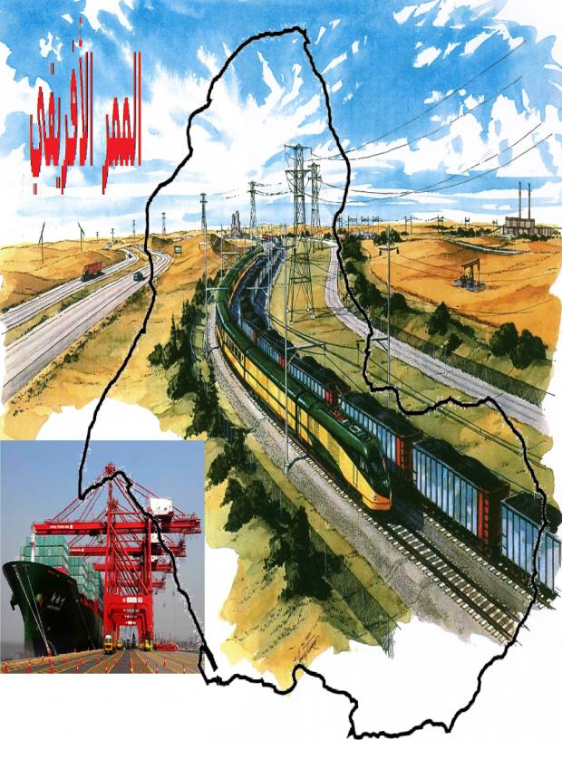
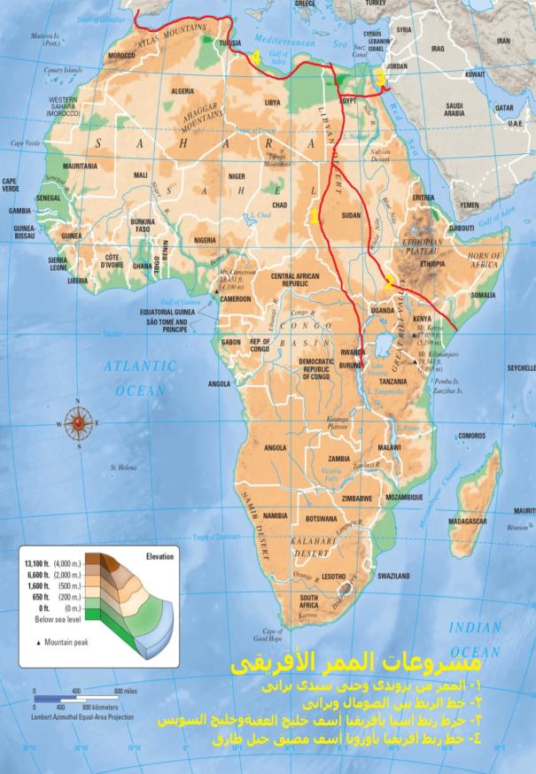
Africa pass Afro-Mediterranean revolutionary project
Introduction I believe that this project
carries good, growth, prosperity, and advancement, not only to the Egyptian
people, but also to the people of 9 African nations, and also to many countries
in Europe and Asia. I worked since 1988 to study, develop, and update it
according the information I acquire or by reviewing of similar projects by
others, and also from the comments I receive on my Page on Facebook. Egypt and whole of Africa are
gathering around this Project, and that is because it is a giant project that
serves all the interests of the whole world, like Suez Canal at time. This
project connects Egypt from the city of Sidy Barany located in Marsa Matrouh
Governorate north west of Egypt, with the heart of Africa in Burundi in Central
Africa, and also connects East Africa, Somalia (The African Horn) and Ethiopia
to the same city, and from it to Europe. The connection with the Center and
East is made by several axles, the most important is modern and advance rail
ways and international high standard ground ways, and a water canal for
electricity generation comes from Rwanda and Democratic Congo and ends at Qattara
Depression in Egypt. The world in the 21st
century is heading towards the Huge Entities, whether politically,
economically, or socially, and other aspect of human life. There are talks about rail ways
network to connect the whole world, that allows to build the Knowledge Cities
and Giant Trains, and also Giant Airplanes and Ships. So, the countries that will not
connect itself with this network and use it to as a routs that serves its
people first will have a civil gap with the developed countries that will push
it back, and world will become Masters and Slaves. Egypt was given a unique and
distinguished geographical location between the contents of the world, some is
considering it as a natural and political asset, and a major resource of wealth
to Egypt, and it was this way at all times, as Egypt was the main passage for
convoys and goods, which derived Portuguese to find a new passage The Cape of
Good Hope, so the role of Egypt declines in the international world trade, but
this role was regained again, and Egypt returned to be the center of trade and
the passage between East and West with opening of Suez Canal for the
international trade at 17th of November 1869, which Hoskins
Described as "it is possible that is some sort of material work of the
humans that affects the nations relations with much deeper form, and it is
difficult to imagine that that it will be made once more within the human
capabilities". Gamal Hamdan, described this
particular situation "Suez Canal is the greatest reduction factor in
geography of marine transport, and redirection of continents, and returned the
Geomatic values, as with a relatively small geographic operation, a whole
continent was reduced, and captured the Cape of Good Hope, and put back the
Arabian East and Egypt in the heart of the world and in the focus of the map. We can say that the Canal regained
life to the genius geographic location of Egypt, as it became the center of
work in world trade, the whole world gets its benefits, but Egypt did not get
economical benefits in a direct and effective form. As the marine transportation has
advanced in a tremendous way after discovering oil as the artery of the
industrial life in the world, and building giant ships with great depths with
capacity reaches million tons, these huge tankers swallowed the smaller
tankers, and aimed for the less expensive route for it, which is the Cape of
Good Hope, which lead to deprive Suez Canal from a great income, and
possibility of doubling in the near future. As the marine transport acquires
84% of the size of international trade, then its development is a development
to the international economy. This development is made through building a rail
way network that serves this trade and reduces the costs of marine
transportation, and increases the efficiency of transport, or discovering new
and huge water passages provides facilitation of marine transport for the Giant
Ships and its quick development. It an obligation for Egypt to face
these changes explicitly, practically, and decisively to keep its international
posture as the main pass of the international trade, and also maximize current
revenues of Suez Canal, and introduces high additional revenues as a result for
expecting the increase of manufacturing giant ships nowadays and in the near
and far future. This is not the only challenge
that Egypt is facing, there are other challenges as over population (120
million at 2025 200 million at 2050), which means that population will be
doubled at 40 years, taking into consideration that all previous developments
plans could not deal with these challenges, and going on working with
development plans only will not be capable to face the huge gap between the
Egyptian people requirements and the current resources. In my view, the solution to make
this Rise is through Africa Pass Project, which connects Sidi Barani at the
Mediterranean and Burundi in Central Africa, and also connects Sidi Barani and
Mogadishu capital of Somalia on the Indian Ocean, to accommodate the shipments
of all the ships that uses Cape of Good Hope, which turned away from Suez
Canal. Also, construction of two Giant Ports with great depth, and building of
the greatest container terminal in the world and the greatest storage for
transit cargo, which will be beneficial to Egypt and other nine African
countries, and will make a leap in the Egyptian and African National Income,
and doubling DGP for all North, Central and East Africa. In case this Project is being
affected, Egypt and the other countries will not be just collectors of transit
fees, or performing limited commercial and marine services, but it will cover
the development requirements in all aspects as human development and creation
of new societies in accordance with the latest scientific systems, also
providing millions of job opportunities for all ages and activities and
specialties in many fields, as for example: 1-
Construction:
building of giant cities that accommodates million of people, with good planned
architectural style. 2-
Mining:
raw materials that constitutes great national asset. 3-
Energy:
generating electricity from the sun 4-
Industry:
introducing of many industries on the Project's outputs. 5-
Transportation:
railways, this Project will be the Greatest Railway ever 6-
International
Trade: A leap in International trade and Industry, and new pass for the trade,
that will costs approximately into half. 7-
Engineering
Constructions: the different constructions, as roads, railways, tunnels, and
bridges along the pass will be an engineering achievement. 8-
Tourism:
all countries will have a giant leap in the tourist numbers 9-
Agriculture:
the cultivated land and agricultural development will increase in Africa, and
exporting of agricultural products will be very easy. Conclusion: * This idea of Africa Pass, directly captures
interest. Also, there is no historical precedence. * This Project will accommodate all the
shipments of giant ships that sail through Cape of Good Hope. Its transit fees
will be five times the current income of Suez Canal, in addition to the added
value through the industrial compounds along the Pass. As there is no national indicator
that hinders execution of this Project, and as the economic revenue is huge for
all countries, we can conclude that the execution of this Project will be the
National African Project for this century and next generations. According to the above, we propose
to execute the Project on three Phases. Starting with construction of ports,
then preparing the Pass and Railways, then building of Cities, all within 2 3
years, as all phases will work in parallel. * This segmentation will allow ease of
financing, as the Project entirely will be financed as Petrol Exploration, and
countries do not have to pay any moneys, but will benefit from the huge
economic revenues. * The effective contribution in solving the
current unemployment problem, and will accommodate a percentage of the new
generations that enters into work, and this is an advantage that is not present
except in Great Projects. * The effective contribution in solving of the
overpopulation around valleys and accommodating millions in the new cities that
accompany construction of this Pass. * The permanent and terminal solution to
problems of the African Horn, specially Somalia, and the other countries
through providing real job opportunities to the people, and the presence of
commercial, industrial, service, and entertainment activities that have room
for them all. * The introduction of residential areas along
the Pass will absorb great percentage of the expected increase of population in
Africa during the next 50 years (will not be less than 200 millions). * This Project, with its giant economical
aspects, will create great opportunities to manufacture trains and ships of
larger size, which will help promote these industries internationally, and will
lead to international economic growth. Egypt, in keeping its geographic
location, is capable to search for a new Pass for International Trade, which
does not compete with Suez Canal, but competes with the greater challenge for
International Prosperity, so this Project will be a safeguard and reserving
Suez Canal income and a security for it. The giant projects on African
countries that comes with this Project, is a matter of a challenge for the
Egyptian will in this age full of local and international conflicts. In brief, this Project is a real
Rise Project, the studies almost passed the preliminary stages, because of the
availability of the Geological information, and also the availability of
marketing studies for the tunnel that connects Spain and Morocco. We should take into consideration
that the World is in a cross road, and indicates a serious changes, especially
in the Middle East. And the new world order reveals over power in all aspects
of economy, especially the gigantic density of capital used in production,
gigantic large economies, gigantic competition, gigantic commercial exchange
rates, and gigantic consumption, gigantic expenditure on scientific research,
in addition to rising of huge industrial centers in the Far East, especially in
China (as a factory for the world), so the Mediterranean gained back his
importance as the heart of the world and as a major economic driver. It the area of assembly and
storage and transit of international trade, after establishing the European
Union as a major economic power, and the expected increase in trade between Far
East and European Union and the East Cost of Unites States of America. This project, with its giant
aspects is a development in the right direction, that will make Egypt a
Logistic Center for the world trade. Description of the Project In simple words, is to make Egypt
as a transit area to all continents, through used of its unexploited lands in
building integrated industrial and commercial societies, as these cities will
be used as storage and depots for world's companies as front warehouses to
minimize time between order of goods and receiving it, and building of
production plants for these companies. It is well known that all countries are
racing to build giant ports to handle containers, and spends billions to that.
So, if we consider this is a Project for handling of containers and
facilitating exports and imports for African countries, and also transit of the
cargo of giant ships that cannot cross Suez Canal, and to store goods and
commodities in front warehouses, then this Project could be considered the
greatest Project ever to handle containers, and output is providing millions of
job opportunities, so Egypt will switch from an exporting labor county into an
importing labor country. But, how it could be done? If we look to the map of Egypt, we
will find that it is in the middle of the world, that is why there is special
importance to Egypt as a place for Giant Projects. This is what I want Egypt to
be. So, I started study this Project, so Egypt will get initially $10 billions,
and $5 billions in the first year due to jobs and internal trade accompanying
the Project. When I started at 1988, I was not
in a hurry. So, I planned it to be a Project that Africa will benefit from, and
becomes in a higher position among other continents. Our continent is richest in the
world, it the continent that was occupied entirely, and its wealth was stolen
and people were enslaved for long years. Nowadays, they still plan to go on
bleeding its natural resources regardless of its people's interests. To ensure the success of this
Project, I watched the interests of all parties, so it would be carried out
without disturbances or interference or obstacles. This Projects guarantees delivery
of resources to the Industrial West in unimaginably low prices, and ensures
sustainable development of African counties, and also avoids conflicts and
ensures stability and prosperity.
In this Project, we will find many
alterations to the projects planned by other countries or entities for its own
personal interests, and that seeks to achieve its goals and interests without
direct costs. Often, it tries to convince under
developed countries that these projects is the only solution, so the poor
people adopts these projects as a National Projects, and carry it out on its
expenses, and make it easy for others to directly benefit from it on his
account.
Looking into the previous and
following maps, that represents the existing and planned roads, and applying it
on some proposed projects, we will find that it fits what I said earlier. It
does not offer any benefits to the countries it passes through, except in very
limited development, and with increase of population density in specific areas.
The Pass proposed here, in
addition to facilitation of transport between Egypt and other countries and
expanding out of the Nile valley and the Delta, its seeks opening of new
development aspects and endless land reclamation, and building new projects in
all aspects. This Project specifically provides
all means for the new generations to explore elements of natural wealth and the
nearest to populated areas, and the most famous Qattara Depression in the
Western Desert. It occupies a large area and its depth is 81 m below sea level,
which make it a fresh water lake, and we can generate electricity from water
that will come into it from the water canal coming from Central Africa to end
in Qattara Depression, and not wasted in the sea, and also Toshka Valley south
west. The main question is what is the
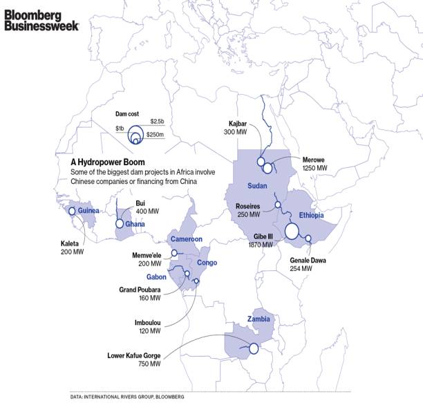
overall cost? The cost of building power stations is answered by this map from
Blumberg Site, and news about the Chinese companies that build hydroelectric
stations in Africa.
This may be for Egypt, as for
Sudan, north and south, the area that the Project is passing through is
semi-desert and Sudan have large lands. So, what is the return? Here, we can mention several
returns, for example: for North and South Sudan, it will provide cooperation
and commerce with Chad and Central Africa. Also, there is possibility for
lateral roads to connect Chad and Central Africa with this Pass to used for
exporting its products and importing its needs. Northern Sudan 1- Sustainable development of Dafour. 2- Building electric power stations on the
downgrade in this area. 3- Opening an exporting window for Meats of
this area. 4- Ending the permanent conflict in this
area, as this Project will offer a lot of services and job opportunities.
Southern Sudan 1- Finding an opening into the Mediterranean. 2- Development of the area that the Project
passes through. 3- Exporting of agricultural tropical
products to Europe in minimum time with low cost. 4- Opening a Petroleum exporting port on the
Mediterranean, so it will maximize its development. 5- Electric power generated along the Pass. 6- Exporting of wood with ease. 7- Political relations and cooperation with
the north. 8- Thousands of job opportunities. Also, the importance of this
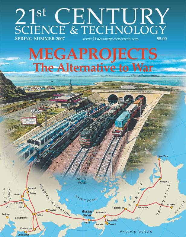
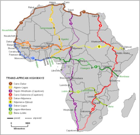
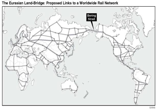
Project is due to many factors, the most important is that many organizations
in the world are planning to connect the world with highways and railroad,
taking into consideration only there interests, not the interests of the
countries that these roads is passing through. They made plans that these roads
will pass through developed areas, and to develop the areas it will pass
through. The following maps and photos give us these plans in Africa and Asia
and the world. Some may ask, why this part of the
western desert is chosen specifically for this Project that will connect us
with the world? There are many oases with its development potential, and there
are roads that can be used and developed as an infrastructure to the Project,
rather than starting from nil. Also, away from Alamain mines, and most
importance overcoming the specific tradition of Egyptians, that travels daily
for 6 hours to return home at the end of the day. In addition, there is an airport
in Sidi Barani, that can be used at the beginning, and there is another airport
at Siwa.
First: Supports of the First Phase The proposal of the first stage of
Africa Pass Project includes: 1- Top grade Container Port in the area of
Sidi Barani. 2- 4 lane railroad (2 lane at first, then 4
lanes) from the Port across all of Egypt and Northern and Southern Sudan and
touches Central Africa, passes through Democratic Congo, Uganda, Rwanda, and
Burundi in Central Africa. 3- Five large cities in Egypt, including the
Port itself, and the cities are 200 km apart, to use the highway and the
railway, as the train speed should be 250-300 km/hour or more. The cities in
the other counties is build in the same rate. 4- International highway parallel to the
railway. 5- Lined water canal 40 m wide and 15 m deep,
designed for low evaporation. It starts in rain falling areas in Central Africa
till Qattara Depression. It will be lines with rolls of plastic sheets and
covered again with sand. In time the sand pores will be filled with mud, which
makes a natural leak prevention after eroding of plastic in 30 to 50 years from
installation. 6- Electric power stations along the canal,
approximately 7 hydroelectric stations, each one will be producing as much as
the High Dam. 7- Fiber Cables for Internet and
communication services along the Pass, which develops communication services in
these countries and gives quick returns for the investor from subscribing to
these services. Also, permits banks and different industries to communicate
with the world. 8- 20 service areas for trailers and vehicles
in Egypt, on areas not less 5 km2 for each. These areas will be
service and entertainment areas that drivers and travelers find all their
needs. They can even spend some nights for recreation. And this example should
be generalized along the Pass in all countries. Second: The
Aim of the Project 1- Cooperation between Egypt and African
countries in all aspects. 2- Switching Egypt from a Labor repellent
country into labor attracting country. 3- Real sustainable development for 9 African
countries, in addition to our beloved Egypt. 4- Finding of exporting port for African
countries on the Mediterranean. 5- All participating countries will get a
percentage for passage. 6- Finding new vast and dense job
opportunities. 7- Moving dense population to new cities. 8- Regain of Egyptian role in Africa. 9- Development of water resources and
generating clean power without conflicts. 10- Reclamation of millions of feddands around
Qattara Depression at the end of canal and not the sides, to ensure flow of
water and to generate electricity. Third: Steps of Implementation 1- Concentrated efforts by Ministry of
Foreign Affairs and Ministry of International Cooperation and the different African
organization to persuade the countries of the importance of this Project. 2- Implementation simultaneously in all
countries. 3- Making maps and designs of roads and
cities, and modifying the pass according to obstacles. 4- Construction of the port. 5- Construction of the double railway. 6- Construction of the water canal. 7- Establishing of cities. 8- Construction of the international road. Forth: Method of Implementation The Project is executed with one
of the following methods: 1- Build Operate Transfer. The concept is
that a private investor, after the necessary governmental authorization, will
build any of the infrastructure projects like airport and power station by his
own resources, provided he will operate and run it for a period of time. Usually,
30 40 years, during which he gets the costs incurred plus profits. After this
period, the project is transferred to the Government. So, BOT means there is
financing mechanism for infrastructure away from the government budget: a- Like the process made at oil exploration. b- The investor spends a specific sum within
certain period, and in return he gets a fixed percentage from the returns. Or,
the percentage is to be graded according to: i. The investor gets all of the returns for
2 years, he gets 70% to 80% of his investment. ii. The Government share is increased to 10%
each year till its share is 80% of the returns and the investor 20%. iii. These percentage remains fixed for 15
years, which ensures that the investor will get all the moneys incurred and
profit, and encourages him to develop the project to get higher profit with
time. iv. After that, the investor gets 10% of the
returns till the projects reach 50 years old, then the Project is returned to
the Government. v. In the second phase of the Project will be
published to connect Saudi Arabia with Sidi Barani with railways and oil line,
passing through Tiran Island, under Gulf of Aqabe, Sinai, under Gulf of Suez,
then to Asiut and connects with Africa Pass in central Egypt. This stage will
start directly after finishing the Port and the industrial and storage area.
Proposed pass for train that
connects Egypt and Saudi Arabia, and crosses Sinai and a large portion of the
Eastern Desert. This the part concerning Egypt and Saudi Arabia, this railway
is to expanded to reach Atlantic ocean at the west and Arabian Gulf in the
east. vi. The third stage of the Project is to
connect Somalia with Sidi Barani with railways and oil line passing Ethiopia
and Southern Sudan and Northern Sudan, and connects with Africa Pass south of
Egypt.
vii. This line serves Suez Canal directly
through Container Port and Oil line, that will enable giant tankers that cannot
cross the canal to download its cargo in Somalia, then pumped through the oil
line to Sidi Barani. Then, using tankers or marine oil lines to Europe. viii. Phase Four of the Project to connect Sidi
Barani and Barcelona with Railways passing through Libya, Tunisia, Algeria, and
Morocco. Then through a tunnel under Gibraltar. 2- Share holding companies Through establishing giant share
holding companies, and making its shares available for the international public.
The government is the owner of the Project, and after specific period of time
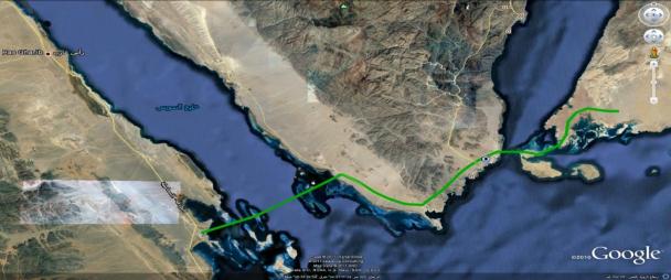
all shares will return to the government. Fifth: Suggested Route The next photo of google showing
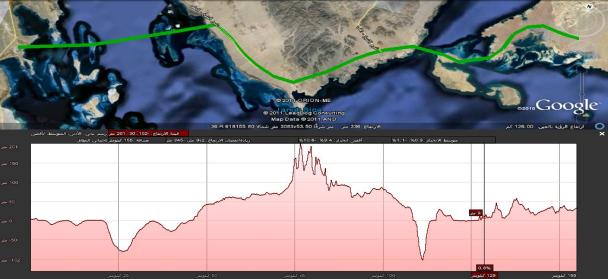
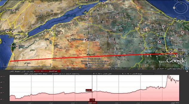
the rout, and elevation along it.
Project Details
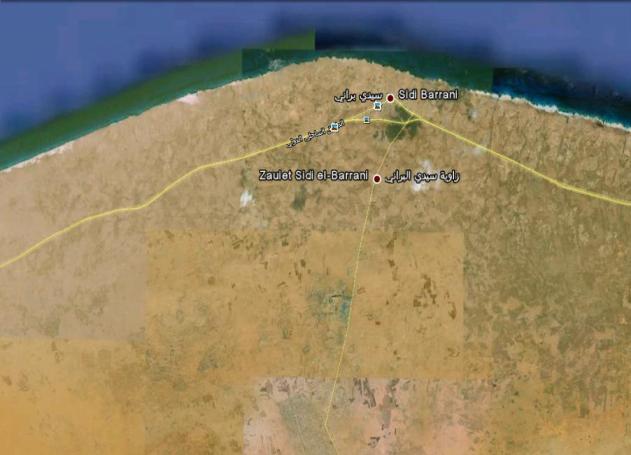
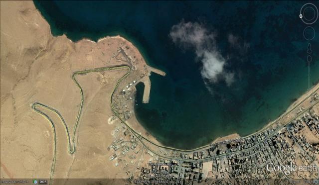
1- Sidi Barani Container Port Sidi Barani was chosen for many
reasons that makes it very special ports on the Mediterranean, such as: a- Sidi Barani is divided into two sections, Costal
Sidi Barani and Zawiet Sidi Barani 20 km on shore. b- The city is 82 km away from Libyan borders,
makes it easy for trade between African countries and Libya. c- An new Giant port in Egypt, with marina
facing El-Salum Plateau, and many great beaches till Marsa Matrouh. d- A new port for marine and desert tourism for
Europe. 2- Sidi Barani Marina a- Construction of a marina and Cruise ships b- All sorts of recreations and leisure and
sports.
3- Sidi Barani Industrial City Construction of International
Industrial City 50 km on shore, connected to the port with highways and
railroads. a- This site would be a free zone. b- The city is divided into 4 or more sections,
so each section would be an assembly of similar or related industries. c- No cars allowed in the city, only railways
and electric transportation means. 4- Sidi Barani City for Warehouses and Depots Construction of a
warehouse and storage sites near the port, occupying the area between the port
and the industrial city, connected with railways and highways. a- This site will be operated as a free zone. b- Providing of road network that accommodates
all maneuvers needed for storage, and provide for safety and firefighting and
emergencies. 5- Sidi Barani International Residence 6- A 4 ways Railway, starting at the port
though whole of Egypt, Sudan, Congo, Uganda, Rwanda, and Burundi in Central
Africa. 7- 7 residential cities including the city of
the port, 200 km apart at least. The train speed should be 250 300 km/hour.
The cities in other countries are to be constructed in the same rate. 8- Highway parallel to the railway. 9- A line water canal 40 m wide 15 m deep,
designed so there is minimum evaporation. It starts at Rainy Central Africa
till Qattara Depression. 10- Power Station along the canal, approximately
7 hydroelectric station, each of them will generate power as much as the High
Dam. 11- Fiber optic cables for internet and
communication services along the Pass, which enables to operate communications
in these countries, and makes quick revenues for the investor, and offers large
communications for different banks and industries. 12- 20 areas for service of trucks, trailers,
and cars on areas not less than 5 km2 for each. These areas is
service and entertainment areas, drivers and passengers will find all their
needs. They could spend several nights for recreation and leisure. The Steps starts with Ministry of
Foreign Affairs, Al Azhar, and Syndicate of Engineers according to the
following sequence: 1- The Pri-minister will hold a conference
for 5 days, to study the Project in full, deciding the course of action. The
attendees are: * Ministry of Planning and International
Cooperation. * Ministry of Transport. * Ministry of Electricity and Energy. * Ministry of Foreign Affairs. * Ministry of Awqaf. * Ministry of Scientific Research. * Ministry of Communications. * Ministry of Housing. * Ministry of Irrigation. * Ministry of Commerce and Industry. * Al-Azhar * Egyptian Syndicate of Engineers. 2- Based on the recommendations of this
conference, the Ministry of foreign affairs will start conferences with the
seven countries the share the Pass, to present the economic benefits of this
Project for each country, and drafting the necessary protocols to ensure smooth
operation. 3- The role of Ministries ,Al-Azhar and
Syndicate of Engineers. a- Ministry of Transportation: Planning,
procurement of labor and equipment necessary to operate the first railway, and
making the necessary studies for rates of flow and constraints, and making
plans for workshop location and administrative buildings, etc. b- Ministry of Electricity and Energy: Making
the necessary planning, calculation of the necessary power required to populate
this Pass, and make the plans and design for power stations. c- Ministry of Al-Awqaf: Making a full plan for
financing Azhar universities and institutes, and financing of scholarships that
may be presented to students of these countries in Egypt. d- Ministry of Education and Scientific
Research: A full plan to receive students of these countries for post graduate
studies in specializations that serves this Projects in the future. e- Ministry of Communications, Ministry of
Housing: Study about the best way to connect these five cities and suburbs, and
its development. f- Ministry of Irrigation, Ministry of Commerce
and Industry: Study support of water supplies, with study of the raw materials
and the best method to transport it to the exporting port. g- Al-Azhar: Build some branches of the
university in these countries, and acts as a promotion and acceptance of this
project. h- Syndicate of Engineers: A consultant for the
Government and making the necessary studies, and engineering support for the
Project. Reasons for the Project: The future of Egypt its leadership
in Africa a boost and motivation of the national interests. The Importance of the Project: 1- Obvious return and strategic depth. It has
definite schedule. It gives a great opportunity for exploiting engineering and
technical ingenuity. 2- Rehabilitation of the population, so the
work is only 6-8 hours daily. So, the people will have time to enjoy their
lives and innovation in their work. The Major Drawbacks: 1- Limited water resources. 2- Necessary resources to develop industry
and increase national income. 3- Unemployment and population bad
distribution. 4- Limited energy, that slows down the
development. Importance of Transportation Transportation is the base for
prosperity. As for Egypt, it needs a whole new transportation network, that
facilitates movement of people and goods, and promotes new styles of living. ملحوظات
عامة: ·
أرى أن تكون
المرحلة
الأولى: سيدى
برانى
الصومال (أو
دار السلام،
تنجانيقا). عن
طريق دول وسط
أفريقيا. هذه
هى المساهمة
الحقيقية فى تقريب
التجارة
العالمية. هذه
هى الخطوة
الجبارة: ربط
البحر
المتوسط
بالمحيط
الهندى مباشرة،
وبذلك تستفيد
جميع الدول
التى يمر بها
هذا الخط. هذه
الخطوة
مكانها
المرحلة
الأولى.. ·
القناة
المقترحة: أرى
أنها محدودة
الجدوى الاقتصادية
مع ارتفاع
خيالى فى
التكلفة.
وبدلا منها
أقترح: خط
أنابيب مياه
على طول الخط،
يبدأ من أحد
بحيرات وسط
أفريقيا،
يخدم مسار
القطار
والمدن
المقامة
عليه.. فلا
يمكن أن تقوم
تنمية فى
الصحراء بدون
مياه. ·
تعليق أخير:
ما هى
التكلفة؟؟؟؟
أرى أن تكون
هناك أرقام
تقريبية
ابتدائية لكل
خطوة، لأنه بدون
هذه الأرقام،
لا نستطيع أن
نحدد القابلية
للتنفيذ أو
مقارنتها
بالعوائد..
تكلفة إنشاء
ميناء تكلفة إنشاء
100 كم سكك
حديدية
تكلفة النقل بالسكك
الحديدية
تكلفة
الكيلومتر من
خط المياه
وهكذا ·
تعليقا على
المرحلة
الثانية، لا
داعى للنفق تحت
خليج السويس
وخليج
العقبة،
التكلفة عالية
جدا والمدة قد
تصل إلى أكثر
من عشر سنوات..
يوجد بديل
مناسب وهو
عبارات
عملاقة، وهى
موجودة، تسع
القطارات
واللوارى
والسيارات.
ويتم اختيار
مكان مناسب بين
مصر
والسعودية
تكون فيه
المسافة
مناسبة ومعقولة،
وتجهيزات
إقامة
الميناء
متوافرة. أما
النفق فيمكن
أن يكون فيما
بعد حسب حجم
النقل. وفقك
الله،، |